Acts relates that after preaching in Philippi, Paul “passed through Amphipolis and Apollonia” on their way to Thessalonica (Acts 17:1). This would have taken Paul westwards along the Via Egnatia. Shortly after leaving the northwestern Amphipolis Gate, the road turned almost due north and followed the base of the hillside for about 450 m before it turned northwest to cross the Krenides River and continue across the plain.
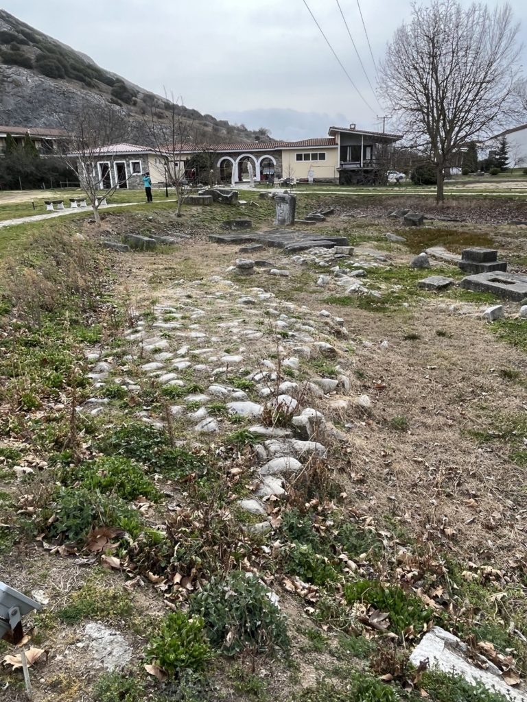
According to Acts 16:13, Paul found the local Jews assembled on the riverside outside the city walls for Sabbath day prayers. Because of this, Lydia was baptized. Today pilgrims have devotions where the ancient road turned and crossed the river, and a modern Greek Orthodox Baptistry and conference center have also been built here. A necropolis normally lined the major roads outside a city, and here a number of ancient Roman tombs are visible. There is also a small section of old paving and some large ashlars that may have been used for the base of a Roman bridge. Thus the site has all the essential features mentioned in the Acts account.
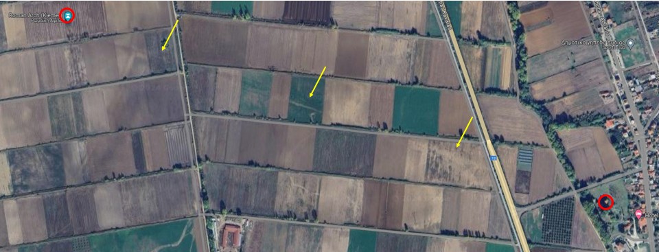
Imagery is ©2025 Airbus, CNES / Airbus, Maxar Technologies with arrows and circles added, Map Data is ©2025 Google
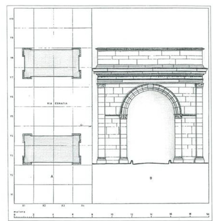
The 16 kilometer-wide plain west of Philippi was very marshy until it was drained in the 1920s and 1930s. In antiquity it was all part of the rural territory (chora) of the Roman colony. In order to avoid the worst part of the marsh the road continued northwest before crossing the plain. The path of the Via Egnatia for first mile or so beyond the baptistry area can be definitively tracked. From the bridge by the baptistry, the road ran for 1.7 km directly to a monumental arch. While only a small number of stones remain today, it was still substantial enough in the mid-19th century to enable L. Heuzey to provide a reconstruction.1 Modern trial trenches and aerial photographs indicating the ancient path confirm this. The width of the road as it ran through the archway was 5.4 meters.
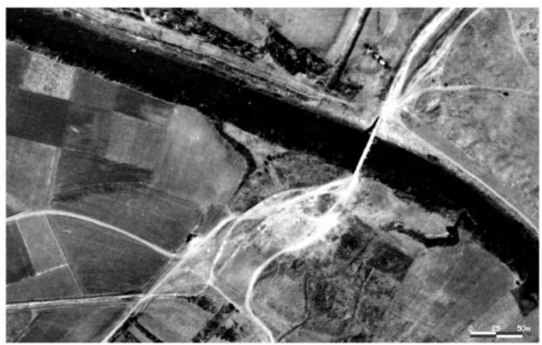
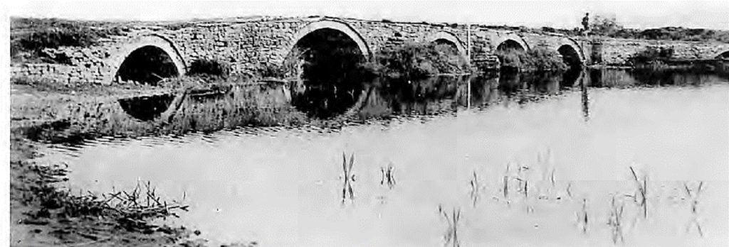
The Gangites River passed within about 50 m west of the arch, and as soon as the VE crossed it, it turned further northwest for about another 1.5 km before turning west and crossing the plain.2 The former marshes, due to a century of cultivation, has hidden all other traces for the next 10 RM. The next concrete evidence we have is a Roman bridge that survived into the twentieth century. Although destroyed when the current road was constructed, photos exist showing the ancient bridge, called the Kourouvo bridge, at that location. The itineraries give the distance from Philippi to Amphipolis as 32 or 33 RM with two stationes in between. Ad Duodecimum was located some 12 RM from Philippi, so it must have been someplace near the Kourovo bridge.3 The path as we have reconstructed it is about 12.3 RM from the Kourovo bridge to the northern gate of Philippi. In rural areas, such stations were often built at crossroads or bridges.
While today there are few visible traces of the road between Philippi and Amphipolis, we will follow the plausible route that has been mapped by Demetrius Kaimaris in his 2006 dissertation. From here the road ran across the drier valley on the west side of Mt. Pangaeus. Based on topography and known roads, it appears that the VE would have followed the path of the current Drama-Protis road for another 7.5 km until, when west of the village of Nea Mpafra, it continued to the southwest along the track of a smaller farm road for another 3.7 km. Brélaz and Tirologos suggest that the second halting place mentioned in the itineraries, statio Domeros, was located near where the road crossed the river southeast of Aggista, perhaps at the site known as Keramides.4 Domeros is listed in the itineraries as 7-8 RM from Ad Duodecimum.
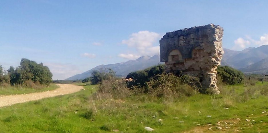
From the bridge near Aggista, the same farm road continues to the southwest for about another 5 RM where it passes a monumental ancient ruin, apparently part of a nymphaeum, known today as Xirovrisi (Ξηροβρυση). Since it is not close to any ancient urban center, this probably served travelers passing on the VE. Milestone 9, now standing outside the Amphipolis Museum, must have been located in the vicinity, about 250 m to the south according to Kaimaris.5
From the Xirovrisi ruin it is another 8.8 RM (13 km) to the northern gate of Amphipolis, following the same farm road to the southwest for much of this. The proposed route runs about 2 km west of the village of Mikro Souli alongside the vestiges of a series of World War I fortifications. This indicates that the route was still important (and in need of defense) right into the twentieth century. This stretch seems to be less straight than expected of a Roman road but, according to local archaeologists, is made up of a series of smaller pre-Roman stretches that adapted to the terrain and its obstacles.6 Milestone 5 was probably located northwest of the current village of Paleokomi.
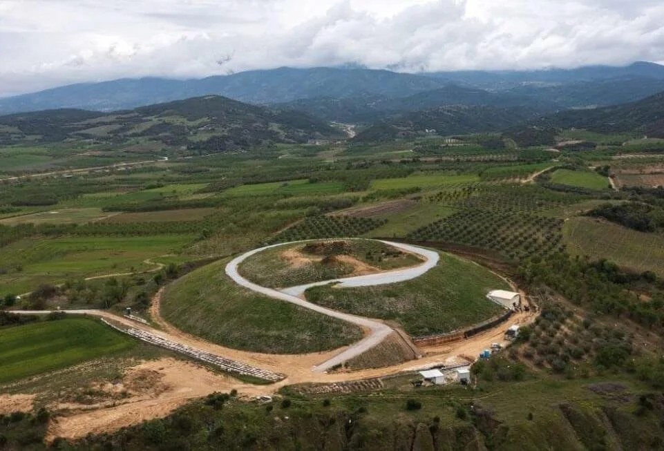
As the VE approaches Amphipolis from the north, it passes some monumental Macedonian-era tombs sited along the pre-Roman road. It probably ran just to the east of the first of those still visible, the Tomb of the Fox, about 2.5 km north of Amphipolis. Over the next RM the path would have slowly curved south and passed between the Kasta tomb and the so-called Hill 133. The late fourth-century BC Kasta Tomb is the largest tumulus ever found in Greece, yet the identification of its occupant(s) is uncertain. Hill 133 was the site of Neolithic and Iron-Age settlements as well as later classical-era cemeteries. About here the party would have passed milestone 1.
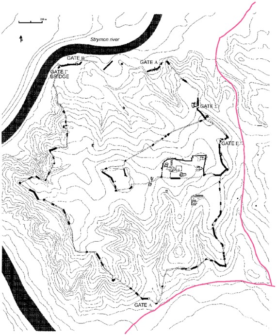
The road continues southwest for another kilometer where we hypothesize that the road split. One track would have continued one final kilometer to the southwest to the still-extant northern gate of Amphipolis. The other road would have continued south around the east side and then west around the south side of the city. There a spur would have run north to the southern gate of the city (today called the Double Gate Α΄), while the main road continued south to cross the Strymon River. The pre-Roman road seems to have followed this path outside the city wall,7 since a small piece of a Macedonian-era milestone was discovered in the area east of the city.
Created by GMT & JTS
Last updated 10-23-2025 JTS
- Heuzey, Léon, and Honoré Daumet. Mission archéologique de macédoine: Ouvrage accompagné de planches. planches par Léon Heuzey et H. Daumet. Paris: Firmin-Didot, 1876, pp. 117-120 and plate 2. ↩︎
- Kaimaris, Demetrius E. Photogrammetric processing of digital images at the service of archaeological research: The Localisation of the Via Egnatia from Amphipolis to Philippi (in Greek). Dissertation, Aristotle University of Thessaloniki, 2006, pp. 198-203 with aerial photos. ↩︎
- See Kaimaris, Photogrammatic processing of digital images, 198-203 with aerial photos. ↩︎
- Brélaz, Cédric, and Georges Tirologos. “Essai de Reconstitution Du Territoire de La Colonie de Philippes : Sources, Méthodes et Interprétations.” In Espaces et Territoires Des Colonies Romaines d’Orient, 119–89. Besançon: Journée d’étude de Besançon, 2016, p. 136. ↩︎
- Kaimaris, Photogrammatic processing of digital images, 221. ↩︎
- Brélaz and Tirologs, “Essai de Reconstitution Du Territoire de La Colonie de Philippes,” 135. ↩︎
- This is the route described by Maniatis, Y, D Malamidou, H Koukouli-Chryssanthaki, and Y Facorellis. “Radiocarbon Dating of the Amphipolis Bridge in Northern Greece, Maintained and Functioned for 2500 Years.” Radiocarbon 52, no. 1 (2010): 41–63, p. 42 fig. 1, p. 58. ↩︎