After about one month of evangelizing in Thessalonica, some jealous Jews stirred up trouble for Paul with the city officials (Acts 17:1-8). As a result the new Christians “sent Paul and Silas away towards Berea” probably with letters of introduction to the Jewish community there whom they thought would be sympathetic to his message.
Judging from modern maps, the trip from Thessalonica to Berea looks like an easy 70 km trip. Even the Barrington Atlas is misleading as the road it shows along the coast did not exist in the first century. The entire area northwest of the Gulf was a vast marsh leading to Lake Loudas. As a result, travelers to Berea had to continue westwards along the VE for another 75 km (almost to Edessa) before turning due south for an additional 35 km in order to reach Berea. This is why Cicero described Berea as “a town off the [Egnatia] Road” (oppidum deuium, In Pisonem 36.89).
The exact route of the VE immediately west of modern Thessaloniki has not been ascertained, due in part to expansive urbanization in modern times. The ancient itineraries are of little help as well. The Antonine lists the distance from Thessalonica to Pellas as 27 RM, the Jerusalem itinerary has it as 30 RM, and the Peutinger map gives the number as 33 RM. Only the Jerusalem itinerary gives any intermediate mutatios, listing 10 RM from Thessalonica to Ad Decimum, another 10 RM to Gephira, and then 10 RM to Pella. The route we suggest is about 26.2 RM measuring from the western gate of Thessalonica to the east side of the agora at Pella, close to the Antonine figure.
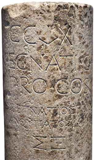
From the Golden Gate, the VE likely continued northwest under or near Monastiriou Street for about 3 km until the modern street turns further north. At that point the VE probably continued straight for another 7.5 km before crossing the Echedoros (modern Gallikos) River. On the west bank of the river one of the original VE milestones (146–120 BC) was uncovered during construction of a vehicle plant in the Sindos industrial area. The bilingual inscription includes the name of Gnaeus Egnatius, the official who oversaw the construction of the highway that was to bear his name.1 According to its inscription, it marked 260 RM (CCLX in Latin and ΣΞ in Greek) from the road’s beginning at Dyrrhachium. Citing Polybius, Strabo gives the distance from that city to Thessalonica as 267 RM (395 km) (Geography 7.7.4). The milestone was found about 7.4 RM (11 km) from the western gate, almost exactly where expected.
From this point to Pella we must reconstruct the path of the VE on the basis of a series of prominent pre-Roman tombs built in commemoration of elite Macedonians. These would have flanked the main pre-Roman east-west road, both for access and for display. The first of these, called the Double Trapeza tomb, is 2.7 km straight past the milestone spot. Somewhere about 1 km further along the same trajectory must have stood the mutatio ad Decimum mentioned in the Jerusalem Itinerary as 10 RM from Thessalonica. Since Paul and Silas left Thessalonica at night (Acts 17:10), they probably had to travel more slowly in the dark and may well have stopped at this mutatio for the night, thus avoiding a possible encounter with robbers (2 Cor 11:26).
About 3.8 km further, the path intersects with the modern Leofóros Athinon that runs westwards through the village of Agios Athanasios. This road may overlay the ancient path since here it passes next to the next major Macedonian tomb. From there the VE continues straight for another 6.5 km and then turned west, following the path of Highway 2 quite closely all the way to Edessa. 600 m later the road crosses the Axios (modern Vardar) River. Papazoglou, however, suggest that the route went several hundred meters further south, passing through the village of Valtochori and on to Chalcidona. These two villages are the best candidates for the location of the ancient city of Allante.2
We are now about 17.5 RM west of Thessalonica. The Jerusalem Itinerary also mentions a mutatio Gephira 10 RM beyond Ad Decimum, i.e., 20 RM from the city. Gephyra means “bridge,” and the Axios is the only major river in the area. Despite the discrepancy of several miles, the mutatio should probably be placed near where Highway 2 crosses the Axios or somewhat further south if one follows the theory of Papazoglou.
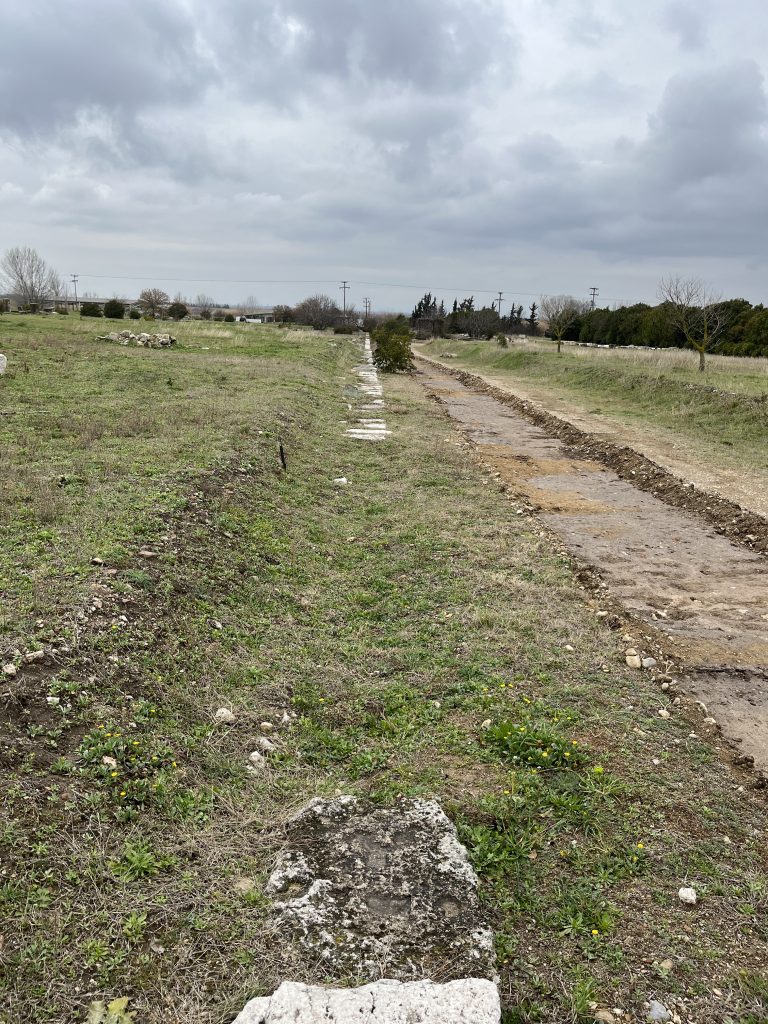
From the village of Chalkidona onwards, the route is more certain. About 1.6 km after the highway exits that village, a series of four Macedonian tombs flank the modern highway at 1-kilometre intervals. Shortly after the final tomb, according to a map displayed in the Pella Archaeological Museum, the VE veered northwest to pass southwest of a multi-chambered tomb. It turned due west 150 m later and ran directly for a final 700 m to the eastern entrance of Pella’s Hellenistic agora. It then continued across its center and out the western side. M. Akamatis calls it “a majestic avenue, fully 15 m across and the largest of the city’s streets,”3 and thus is most likely the VE. Both a first-century BC earthquake and the re-founding of the city as a Roman colony would have entailed extensive changes to the city plan which in turn may have altered the route of the VE through the city.
Created by GMT & JTS
Last updated 11-04-2025 JTS
- CIL I2 2977 = AE 1973, 492 = AE 1976, 643. The text reads Gn(aeus) Egnati(us) G(aius) f(ilius)/Pro.co(n)s(ul)/ Γναῖος Ἐγνάτιος Γάϊου ἀνθύπατος Ῥωμαίων. The stone is now in the Archaeology Museum of Thessaloniki (MΘ 6932; see Romiopoulou, Catherine. “Un Nouveau Milliaire de La Via Egnatia.” Bulletin de correspondance hellénique 98, no. 2 (1974): 813, n. 1. ↩︎
- Papazoglou, Fanoula. Les villes de macédoine a l’époque romaine. Athènes, Paris: Ecole française d’Athènes, dépositaire: Diffusion de Boccard, 1988, pp. 182–83. ↩︎
- Akamatis, I. M. “Pella.” Essay. In Brill’s Companion to Ancient Macedon, 393–408. Berlin: Brill, 2011, p. 397. ↩︎